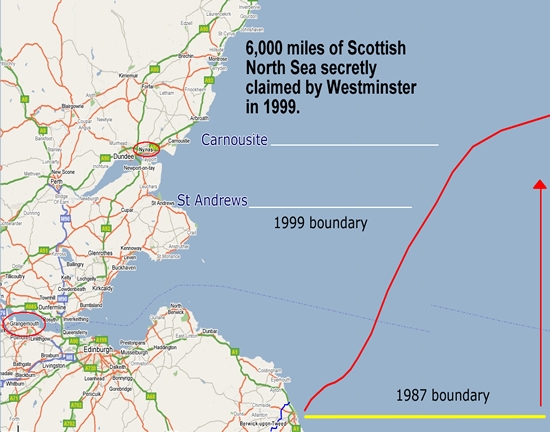
According to existing Westminster legislation, English waters stretch at their North Easterly point to 56 degrees 36 minutes north – that is over 100 miles North of the border at Berwick, and North of Dundee.
In 1999 Tony Blair, abetted by the Scottish traitor Donald Dewar, redrew the existing English/Scottish maritime boundary to annex 6,000 square miles of Scottish waters to England, including the Argyll field and six other major oilfields. The idea was specifically to disadvantage Scotland’s case for independence.
The pre-1999 border was already very favourable to England. In 1994, while I was Head of the Maritime Section of the Foreign and Commonwealth Office, I had already queried whether it was too favourable to England. I little anticipated that five years later Blair would push it seventy miles North!!
I should explain that I was the Alternate Head of the UK Delegation to the UN Convention on the Law of the Sea, and was number 2 on the UK team that negotiated the UK/Ireland, UK/Denmark (Shetland/Faeroes), UK/Belgium, and Channel Islands/France maritime boundaries, as well as a number of British Dependent Territories boundaries. There are very few people in the World – single figures – who have more experience of actual maritime boundary negotiation than me.
The UK’s other maritime boundaries are based on what is known formally in international law as the modified equidistance principle. The England/Scotland border was of course imposed, not negotiated. It is my cold, professional opinion that this border lies outside the range of feasible solutions that could be obtained by genuine negotiation, arbitration or judgement.
It ignores a number of acknowledged precepts in boundary resolutions, most important of which is how to deal with an inverted right angle coastline, as the Scottish coastline is from Elgin to Berwick, with the angle point around Edinburgh. It also fails adequately to close the Forth and Tay estuaries with baselines – by stark contrast to the massive baselines the UK used across the Thames and Stour.
It is essential that Scotland is not conned into accepting the existing England Scotland maritime boundary as a precondition of any independence referendum. This boundary must be subject to negotiation between equal nations post independence, and in my opinion is most likely to end with referral to the International Court of Justice. I have no doubt the outcome would be a very great deal better for Scotland than the Blair-Dewar line, which would cost Scotland billions.

Dear Craig,
This issue continues to roll around the grumble bin (yet another online petition that will get ignored). While I entirely agree with you that this move was/is Just Plain Wrong, what I also tripped over this morning was how this has affected GERS figures. I wonder if you know someone clever enough to quantify, this never ratified by any Parliament ongoing THEFT from the Scottish people?.
Cheers mate, keep up the good work.
Iain
But Craig, according to your own Bio, you were NOT “Head of the Maritime Section of the Foreign and Commonwealth Office” in 1994 as you claim here.
Are you floating your own boat, again?